
 Pamplona Comprehensive Land Use Plan
Commissioned by former Sen. John H. Osmeña and the Pamplona Plantation Holdings Inc., the Pamplona Comprehensive Land Use Plan positions Pamplona to be the host of the latest and the only integrated tourism- commercial-residential complex in Negros Oriental. Anchored on Pamplona Holdings Inc. development objectives, Pamplona sets to be the new economic phenomenon of Negros Island.
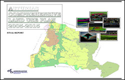 Asturias Land Use Plan
Unlike the other land use plans in the province, Asturias hopes to become the agro-industrial and mining destination of Cebu Province. It also envisions to be the health tourism destination by capitalizing and developing its Cebu’s only hot spring ever situated in the seashore area.
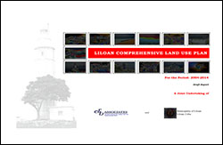 Liloan Land Use Plan
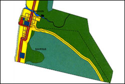
The Liloan Comprehensive Land Use Plan (LCUP) is a follow up to the Liloan Development Master Plan (LDMP) formulated by the Palafox Associates in order to comply the regulatory requirements pertaining to passage of land use plan as mandated by Executive Order 72 and Republic Act 7160 which is famously known as 1981 Local Government Code.
 Medellin Land Use Plan
A primary sugar town in Cebu, the local government unit of Medellin wants to attract tourism development and agro-industry investments into the town through a land use plan document. The plan envisions the municipality to be the gateway of tourism and investments in northern Cebu. The plan was formulated to complement and in consonance to the controversial agrarian reform law being implemented in the municipality.
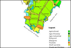
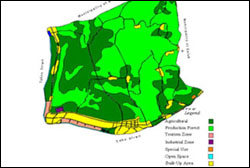
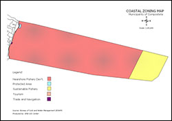 Compostela Integrated Land Use Plan
The Compostela Integrated Land Use Plan (CILUP) was formulated by ER&B Associates as the first planning document in Cebu incorporating and institutionalizing the coastal and forestal areas into an HLURB-prescribed land use plan. Uses and regulations pertaining to coastal and forestall areas were also incorporated into a zoning ordinance.
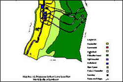
 Santa Fe Tourism and Land Use Plan
One of prime tourist destinations in Cebu, the Municipality of Santa Fe makes it a policy to integrate the tourism development and land use component into one plan document. As a result, an integrated tourism and land use plan was conceived. The tourism and land use plan envisions the municipality to be the gateway of tourism and investments in Bantayan Island. Establishment of tourism zone, agro-industrial zone, protected areas, marine sanctuaries, conservation zone and restricted zone were adopted.
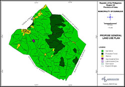 Dumanjug Strategic Land Use Plan
Using the latest planning methodology available, Dumanjug land use plan was formulated by ER&B Associates using the strategic planning approach advocated by the Housing and Land Use Regulatory Board (HLURB). The Dumanjug Strategic Land Use Plan (DSLUP) supports the establishment of city-like facilities in a rural setting for the municipality of Dumanjug.
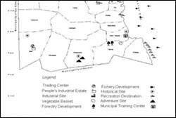 Tabogon Development and Land Use Plan
The Tabogon Development and Land Use Plan (TDLUP) is basically a development plan for the municipality of Tabogon. It, however, incorporates the land use component as physical policy and as regulatory tool in the implementation of the TDLUP. Under the plan, the municipality of Tabogon shall be divided into three (3) “economic districts or zones”. The southern zone shall be the tourism gateway, the northern zone shall be the industrial site, while the central zone as the institutional and trading center.
 Santander Comprehensive Land Use Plan
The Santander Comprehensive Land Use Plan (SCLUP) aims the municipality of Santander to become an emerging agro-industrial center in the province and the gateway of southern Cebu for tourism, transportation, and investments. Specifically, the municipality sets to fulfill the following role: 1) major producer of agricultural products; 2) site of agro-industrial and light industry estates; 3) major port of entry in Cebu Province; and 4) major tourist destination.
 Samboan Land Use Plan
The Samboan Land Use Plan (SLUP) supports the realization of the town’s planned development; an integrated transportation network, competitive agriculture sector, empowered human resources, and preserved natural resources. The SLUP has been developed through a public participatory process in which a broad range of alternatives is considered. The planning process is conducted through interviews with local officials, residents and experts, consultations, focus group discussions, and a field survey.
 Ginatilan Land Use Plan
Ginatilan’s land use plan is actually a compromise between two approaches; the first, based on the view that land is a shared resource and second, land viewed as a private property – to be owned or sold. The plan is therefore, formulated aimed at promoting the maximum and optimum utilization through rational allocation and delineation of different land uses. The plan also hopes to improve the productive capacity of the municipality without ignoring its environmental condition.